Nearby Villages
(click on symbol to see the village page) |
| Village= | |
Town= | |
Recorded in Domesday= |  |
|
|
|
|
Barcombe |
(Village in three places) | | 5.94 miles |
|
|
Blackboys |
(Charcoal and Soot) | | 0.99 miles |
|
|
Buxted |
(The first Iron Cannon in England) | | 1.74 miles |
|
|
Chiddingly |
(Walking on Cheese ??) | | 4.95 miles |
|
|
Cross in Hand |
(The Crusaders Assembly) | | 4.22 miles |
|
|
East Hoathly |
(Another Sussex Cannibal?) | | 3.14 miles |
|
|
Fairwarp |
(Charcoal and the Army) | | 4.16 miles |
|
|
Five Ashes |
(Vast collection of rock plants) | | 4.82 miles |
|
|
Fletching |
(Simon de Montfort and Jack Cade) | | 4.57 miles |
|
|
Hadlow Down |
(Wealden Cannons and Charcoal) | | 3.26 miles |
|
|
Halland |
(Ancient Slaughter) | | 2.46 miles |
|
|
Heathfield |
(19th Century Natural Gas) | | 5.61 miles |
|
|
Horam |
(Which Station do we get off at ?) | | 5.47 miles |
|
|
Isfield |
(Simon de Montfort and the Lavender Line) | | 3.45 miles |
|
|
Maresfield |
(Soldiers and Iron) | | 2.89 miles |
|
|
Mayfield |
(Saint Dunstan and the Devil) | | 7.05 miles |
|
|
Newick |
(Killer Cricket and Dirk Bogarde) | | 5.02 miles |
|
|
Piltdown |
(The Piltdown Man hoax) | | 3.33 miles |
|
|
Sheffield Park |
(Capability Brown and the Bluebell Line) | | 5.86 miles |
|
|
Uckfield |
(Traction Engine destroys bridge) | | 1.42 miles |
|
|
Vines Cross |
(Cannons and Doodlebugs) | | 6.34 miles |
|
|
Waldron |
(Fullers Earth) | | 3.44 miles |


 Framfield in East Sussex in East Sussex in the South East of England lies in the
inland hills of the county.
It is though that Celtic settlers then the
Framfield in East Sussex in East Sussex in the South East of England lies in the
inland hills of the county.
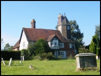
It is though that Celtic settlers then the 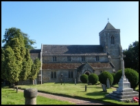 Framfield in East Sussex has one of the prettiest church entrances in the area with
a row of medieval houses leading down to the lychgate then into the
churchyard the only thing to mar this view are the rows of cars in
front.
Framfield in East Sussex has one of the prettiest church entrances in the area with
a row of medieval houses leading down to the lychgate then into the
churchyard the only thing to mar this view are the rows of cars in
front.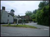 Framfield in East Sussex is a small village with a few local services, shops and
public houses.
Framfield in East Sussex is a small village with a few local services, shops and
public houses.


